

Step One – Map Existing Site and Vegetation
go.ncsu.edu/readext?811970
en Español / em Português
El inglés es el idioma de control de esta página. En la medida en que haya algún conflicto entre la traducción al inglés y la traducción, el inglés prevalece.
Al hacer clic en el enlace de traducción se activa un servicio de traducción gratuito para convertir la página al español. Al igual que con cualquier traducción por Internet, la conversión no es sensible al contexto y puede que no traduzca el texto en su significado original. NC State Extension no garantiza la exactitud del texto traducido. Por favor, tenga en cuenta que algunas aplicaciones y/o servicios pueden no funcionar como se espera cuando se traducen.
Português
Inglês é o idioma de controle desta página. Na medida que haja algum conflito entre o texto original em Inglês e a tradução, o Inglês prevalece.
Ao clicar no link de tradução, um serviço gratuito de tradução será ativado para converter a página para o Português. Como em qualquer tradução pela internet, a conversão não é sensivel ao contexto e pode não ocorrer a tradução para o significado orginal. O serviço de Extensão da Carolina do Norte (NC State Extension) não garante a exatidão do texto traduzido. Por favor, observe que algumas funções ou serviços podem não funcionar como esperado após a tradução.
English
English is the controlling language of this page. To the extent there is any conflict between the English text and the translation, English controls.
Clicking on the translation link activates a free translation service to convert the page to Spanish. As with any Internet translation, the conversion is not context-sensitive and may not translate the text to its original meaning. NC State Extension does not guarantee the accuracy of the translated text. Please note that some applications and/or services may not function as expected when translated.
Collapse ▲Develop a Base Plan and Site Inventory
Landscape design is a creative problem-solving process. It involves developing a design that is tailored to your site, meets your needs and desires, and also provides valuable wildlife habitat. Before you begin to make landscape improvements, identify opportunities and assets as well as constraints and liabilities. To help organize this information, you will need an accurate map of your property on which to record your observations and subsequent analysis.

A typical plot plan. Design by Patricia Lindsey
A typical plot plan includes a drawing scale, for instance, 1”=40’, which means that every inch on the map is equal to 40’ on your property. Plot plans need to be enlarged to allow you to show more details of the landscape. You can take your plan to a copy shop and have it enlarged to a minimum of 1”=10’ for smaller properties or small areas of your garden, or up to 1”=20’ for larger properties. The plan should have the north arrow on it as well, which will be needed to assess your growing conditions.
Base Map

Sample Base Map Outline. Design by Patricia Lindsey
Create an accurate base map that shows all existing permanent physical site elements. When purchasing your house, you may have received a property survey, also called a plat or plot plan of your property. This typically includes the lot configuration, right-of-ways, sidewalks, easements, and position and dimensioning of the house (and permanent structures such as decks and steps), garage, and driveway. If you don’t have one, request one from the tax assessor’s office or download a copy from your county’s GIS website. You can also develop one from your own field measurements, but that will take you longer.
On the base map of your property, show the property lines and house footprint. On this sample base map, information from the plot plan has been re-drawn on 5 x 5 graph paper (when 1”=10’, each square equals 2’). If your property or area of interest is larger, adjust the scale of your squares as needed. For instance, 1” could equal 20’, which would make each square equal to 4’. You can use a plot plan you had enlarged or take the dimensions directly off the original plot plan.
Existing Features
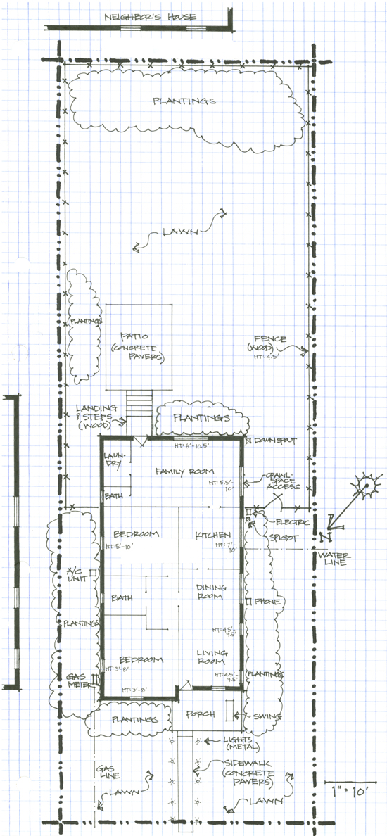
Sample Base Map with existing features. Design by Patricia Lindsey
Include the location of windows, doors, downspouts, spigots, HVAC units, drier vents, etc. Make several copies of your base map. You can use the copies to complete your inventory and site analysis and to sketch out your design ideas.
Map and Inventory Existing Vegetation – Next, identify the existing vegetation on a copy of your base map.
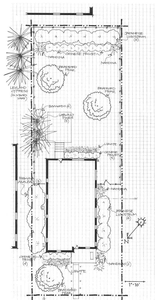
Sample Base Map with existing vegetation. Design by Patricia Lindsey
Locate each plant or group of plants on your base map. Include trees, shrubs, vines, flowers, ground covers, and grasses – everything that is growing in your landscape. Identify which are welcome and which to consider removing from your landscape by:
- using the Extension Gardener Plant Toolbox to learn more about each plant. Type the common or botanical name into the “Search” box in the upper right corner to review the plant profile.
- Review this list of invasive non-natives.